Kansas and Oklahoma
936,989 so'm
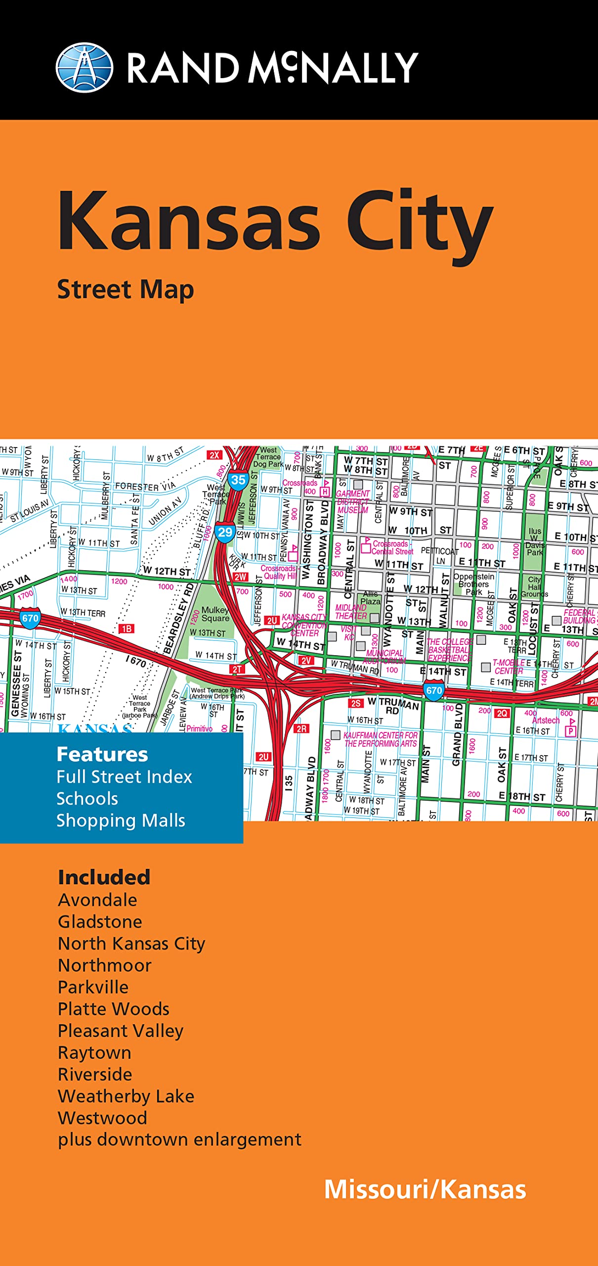
Rand McNally Folded Map: Kansas City Street Map
574,799 so'm

Rand McNally State Maps: Kansas and Missouri (2 Maps)
246,858 so'm

Rand McNally Easy to Read! Kansas State Map
329,749 so'm

USA 08 South rkh r/v (r) wp GPS: Kansas - Oklahoma - Texas
645,369 so'm

Cool Owl Maps Kansas State Wall Map Poster Rolled 24"Wx30"H (Laminated)
350,627 so'm

Driving Across Kansas: A Guide to I-70
1,489,659 so'm

Rand McNally Easy to Read Folded Map: Kansas State Map
146,402 so'm
Rand McNally Folded Map: Kansas City Street Map
1,043,679 so'm

Family Maps of Meade County, Kansas
273,229 so'm

Leavenworth Map Journal: Vintage Map Notebook
697,369 so'm

Family Maps of Ford County, Kansas
2,031,069 so'm

Rand McNally Easy To Read: Kansas State Map
92,379

Vintage Lined Notebook Greetings from Kansas, Map
845,129 so'm

Kansas State Map for Students - Pack of 30
1,494,009 so'm

FISH KISS® Kansas Map Dish Towel, Super Absorbent Kitchen Towel - 16" x 24", Kansas Map Tea Towel, Kansas Map Dish Cloth, Kansas Map Baby Burp Cloth, Kansas Map Bar Towel
1,566,549 so'm
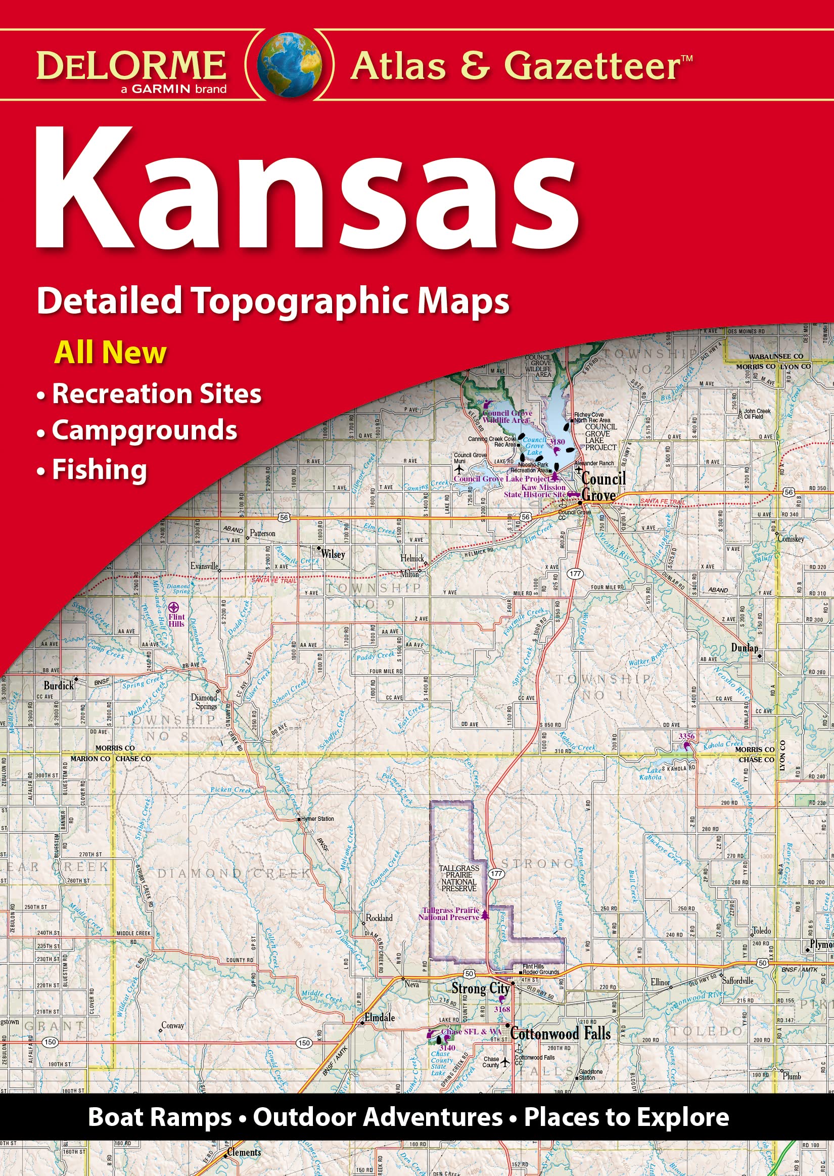
DeLorme Atlas & Gazetteer: Kansas
428,638 so'm

Historical Atlas of Kansas
1,578,749 so'm

The Illustrated Route 66 Historical Atlas
2,121,139 so'm

Kansas Map Journal: Vintage 1891 Map of Kansas Notebook (6"x9" Blank Lined Journal, 200 pages)
901,809 so'm

Rand McNally Easy To Fold: Kansas & Nebraska State Laminated Map
636,719 so'm

Topeka / Lawrence, Kansas Street Map
994,169 so'm
Rand McNally Easy To Read Folded Map: Kansas State Map
123,676 so'm

Tiger Moon The Tiger Moon Trading Company Ltd Kansas State Physical Map - 16.5 x 27.5 Inches - Paper Laminated
377,347 so'm

Kansas City Map Journal: Vintage 1907 Map of Kansas City Notebook (6"x9" Blank Lined Journal, 200 pages)
755,709 so'm
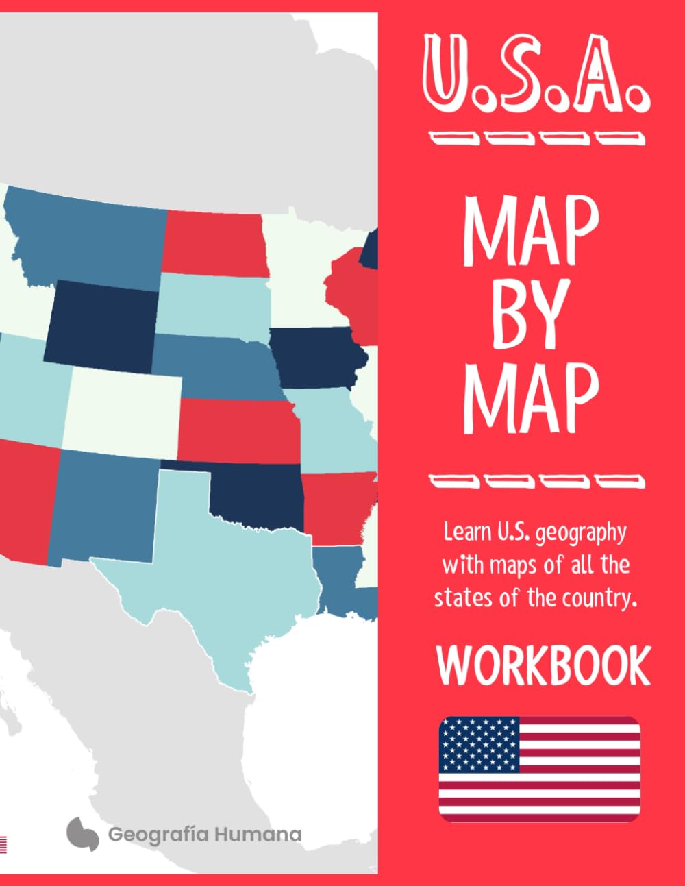
U.S.A. Map by map: Learn United States geography with maps of all the states and territories of the country
648,109 so'm
Vintage Lined Notebook Greetings from Kansas, Map
1,010,039 so'm

Kansas America USA Map Outline Poker Playing Card Funny Hand Game
323,946 so'm

Kansas Map Pull Apart Cooking Kitchen Bib Apron With Pockets Aprons For Women Men Baking Gardening
6,560,919 so'm

BLUPARK Kansas City Map Roller Ballpen Kansas Souvenir Gift Kansas Heartbeat Ballpoint Pen Kansas Mom Dad Gift (Kansas)
1,046,629 so'm

Kansas Vintage Map Field Journal Notebook, 50 pages/25 sheets, 4x6
1,054,049 so'm

VERRE ART Printed Framed Canvas Painting for Home Decor Office Wall Studio Wall Living Room Decoration (14x10inch Wrapped) - Kansas Colorful Watercolor Map Print
431,909 so'm

Kansas Map Matted Framed Art by Michael Tompsett in Black Frame, 16 by 20-Inch
17,527,729 so'm

the Great State of Kansas : notebook Vintage Missouri Map Funny
191,163 so'm

Kansas City & Vicinity, Kansas Missouri Regional Map
505,339 so'm

Kansas Counties Map - Standard - 36" x 22.75" Laminated
2,550,859 so'm
Rand McNally Easy to Fold: Kansas & Nebraska State
656,169 so'm

HISTORIX Vintage 1898 Kansas State Map - 18x24 Inch Vintage Map of Kansas Wall Art Decor - Old Kansas Map Poster Showing County Seats Land Offices Indian Reservations and Railroads
2,914,449 so'm

NFL Kansas City Chiefs Unisex Kansas City Chiefs Mini Roadmap State Sign, Team Color, 12 inch
2,639,489 so'm
Family Maps of Ford County, Kansas
661,713 so'm

Rand McNally State Maps: Kansas and Oklahoma (2 Maps)
243,986 so'm

Hand-Book to Kansas Territory and the Rocky Mountains' Gold Region: Accompanied by Reliable Maps and a Preliminary Treatise on the Pre-Emption Laws of the United States.
425,131 so'm

Kansas, Oklahoma, Missouri and Arkansas Physical Poster Map - 23.3 x 16.5 Inches - Paper Laminated
419,114 so'm

Map of Kansas 18x24 - Laminated Wall Map Poster Print Perfect for Classrooms and Homes - Vivid Imagery with Bright Colors
805,859 so'm

VERRE ART Printed Framed Canvas Painting for Home Decor Office Wall Studio Wall Living Room Decoration (22x14inch Wrapped) - Kansas Colorful Watercolor Map Print
431,909 so'm
Family Maps of Ford County, Kansas
652,428 so'm

Kansas State Jumbo Map Magnet
376,503 so'm

36x52 Kansas State Official Executive Laminated Wall Map
1,531,649

no/no Kansas America USA Map Outline Basketball Postcard Set Thanks Card Mailing Side 20pcs
1,272,169 so'm

VERRE ART Printed Framed Canvas Painting for Home Decor Office Wall Studio Wall Living Room Decoration (14x14inch Wrapped) - Kansas Colorful Watercolor Map Print
345,419 so'm
Rand McNally Folded Map: Kansas City Street Map
203,032 so'm

VERRE ART Printed Framed Canvas Painting for Home Decor Office Wall Studio Wall Living Room Decoration (22x22inch Wrapped) - Kansas Colorful Watercolor Map Print
604,999 so'm

Family Maps of Meade County, Kansas
2,162,589 so'm

Kansas State Wall Map - 20.75" x 18.5" Laminated
9,402,319 so'm

VERRE ART Printed Framed Canvas Painting for Home Decor Office Wall Studio Wall Living Room Decoration (34x22inch Wrapped) - Kansas Colorful Watercolor Map Print
871,359 so'm

Kansas City Map Coaster, Set of 4, Sapele Wooden Coaster with city map, Multiple city optional, Handmade
6,742,589 so'm
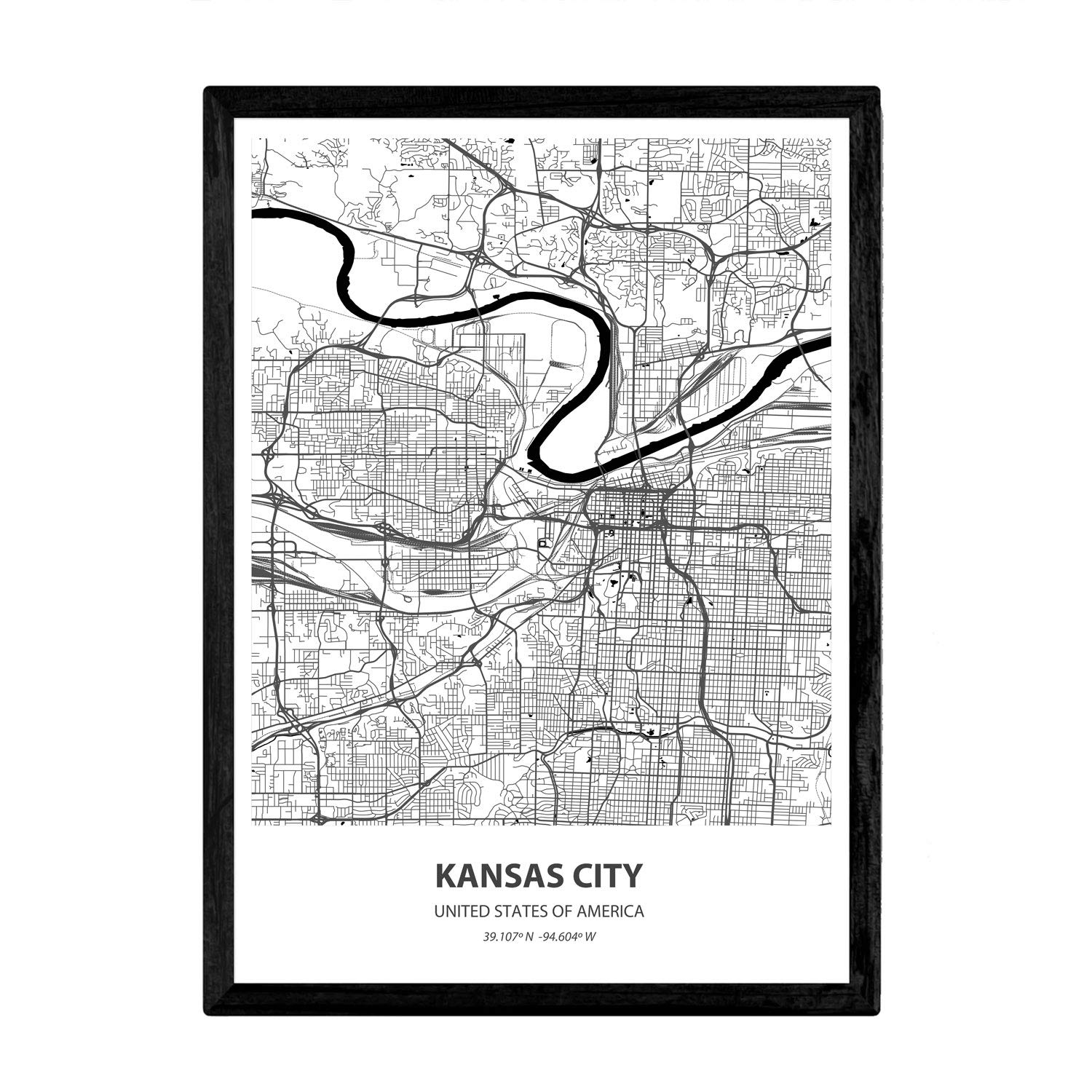
Nacnic Poster with map of Kansas City - USA. Sheets US cities with seas and rivers in black color. A4 size
953,489 so'm

IndiHaatStore Fridge Magnet of Kansas, The Sunflower State, USA, United States of America, Map Shape and Magnet, Yellow with Green Outline, State Rubber Magnet Size 2.25x1.25 inches Approx
363,549 so'm
Family Maps of Meade County, Kansas
654,657 so'm

Eleville 11X14 Unframed Kansas United States Country View Abstract Road Modern Map Art Print Poster Wall Office Home Decor Minimalist Line Art Hometown Housewarming wgn173
1,296,729 so'm
Rand McNally Easy to Read Folded Map: Kansas State Map
634,039 so'm

Outlines Of Kansas History: With Notes, Maps And References
326,833 so'm
Get the App